

Clouds are classified mainly by their appearance and altitude. The World Meteorological Organization (WMO) recognizes ten main types, grouped into four families based on height.
1. High Clouds (Above 20,000 ft) – เมฆสูง
- Cirrus (Ci) – Thin, wispy clouds. Usually a sign of fair weather but can indicate an approaching warm front.
- Cirrostratus (Cs) – Thin, veil-like clouds covering the sky, often producing a halo around the sun or moon.
- Cirrocumulus (Cc) – Small, white patches, often in ripples; sometimes called “mackerel sky.”
2. Middle Clouds (6,500 – 20,000 ft) – เมฆกลาง
- Altostratus (As) – Gray or bluish sheets covering the sky, often preceding continuous rain.
- Altocumulus (Ac) – White or gray patches forming layers or waves, can signal unsettled weather.
3. Low Clouds (Surface – 6,500 ft) – เมฆต่ำ
- Stratus (St) – Uniform gray clouds, covering the sky like a blanket; can bring drizzle or mist.
- Stratocumulus (Sc) – Low, lumpy clouds, often with breaks of blue sky; less likely to bring heavy rain.
- Nimbostratus (Ns) – Thick, dark layers covering the sky, producing steady and prolonged rain or snow.
4. Clouds with Vertical Development – เมฆก่อตัวในแนวดิ่ง
- Cumulus (Cu) – Puffy, cotton-like clouds with flat bases; generally fair weather, but can grow.
- Cumulonimbus (Cb) – Towering thunderstorm clouds; bring heavy rain, lightning, turbulence, hail, and severe hazards for aviation.
✈️ Pilot’s Note:
- Cumulonimbus (Cb) is the most dangerous cloud for flight operations. It is associated with turbulence, icing, wind shear, and lightning.
- Recognizing clouds is not just academic—it’s a vital skill in flight planning and in-flight decision-making.
Cloud Types and Aviation Impact
| Cloud Type | Height | Appearance | Weather | Aviation Impact |
|---|---|---|---|---|
| Cirrus (Ci) | High (>20,000 ft) | Wispy, feather-like | Fair weather, possible sign of approaching front | Generally no hazard |
| Cirrostratus (Cs) | High | Thin veil, halo around sun/moon | Precedes warm front, light precipitation | May indicate deteriorating weather |
| Cirrocumulus (Cc) | High | Small ripples, “mackerel sky” | Fair, but unstable aloft | Rarely hazardous |
| Altostratus (As) | Middle (6,500–20,000 ft) | Gray/blue sheets, cover sky | Continuous rain/snow likely | Obscures terrain, potential icing |
| Altocumulus (Ac) | Middle | White/gray patches, waves | Possible thunderstorms later | Moderate turbulence, icing risk |
| Stratus (St) | Low (<6,500 ft) | Gray uniform layer | Drizzle, fog-like | Low visibility, ceiling restriction |
| Stratocumulus (Sc) | Low | Lumpy, broken cloud | Light rain possible | Generally not hazardous, but lowers ceiling |
| Nimbostratus (Ns) | Low–Mid | Thick, dark, widespread | Steady rain/snow | Significant visibility reduction, icing |
| Cumulus (Cu) | Vertical | Puffy, cotton-like | Fair weather (small Cu) | Moderate turbulence if growing |
| Cumulonimbus (Cb) | Vertical (surface–>40,000 ft) | Towering, anvil top | Thunderstorms, heavy rain, hail, lightning | Severe hazard: turbulence, wind shear, icing, lightning |
✈️ Pilot’s Insight:
- Avoiding Cumulonimbus (Cb) is a golden rule. Even with today’s advanced radar, detouring around storm cells is mandatory for safety.
- Altostratus and Nimbostratus often signal long periods of poor visibility—critical for approach and landing planning.
- Low stratus can reduce ceiling below landing minima, forcing diversion.
ชนิดของเมฆและผลกระทบต่อการบิน
| ชนิดเมฆ | ระดับความสูง | ลักษณะ | สภาพอากาศ | ผลกระทบต่อการบิน |
|---|---|---|---|---|
| Cirrus (Ci) | สูง (>20,000 ฟุต) | เมฆขาวบางเป็นเส้นขนนก | อากาศดี แต่บ่งบอกการเปลี่ยนแปลง | ไม่เป็นอันตราย |
| Cirrostratus (Cs) | สูง | บางคล้ายผ้าคลุม เห็นวงแสงรอบดวงอาทิตย์/ดวงจันทร์ | มักเกิดก่อนแนวอากาศอุ่น ฝนกำลังมา | สัญญาณอากาศแย่ลง |
| Cirrocumulus (Cc) | สูง | เม็ดเล็ก ๆ คล้ายเกล็ดปลา “มักเคอเรลสกาย” | อากาศดี แต่แสดงถึงความไม่เสถียร | อันตรายน้อย |
| Altostratus (As) | กลาง (6,500–20,000 ฟุต) | สีเทา/น้ำเงิน ปกคลุมทั่วท้องฟ้า | ฝนตกหรือหิมะต่อเนื่อง | บดบังภูมิประเทศ เสี่ยงน้ำแข็งเกาะ |
| Altocumulus (Ac) | กลาง | ก้อนสีขาว/เทา เรียงเป็นระลอก | มีโอกายเกิดพายุฝนฟ้าคะนอง | ความปั่นป่วน-น้ำแข็งเกาะ |
| Stratus (St) | ต่ำ (<6,500 ฟุต) | ชั้นสีเทา เรียบ เหมือนหมอก | ฝนปรอย หมอกหนา | ทัศนวิสัยต่ำ จำกัดเพดานบิน |
| Stratocumulus (Sc) | ต่ำ | ก้อนล่างเป็นชั้น ๆ มีช่องฟ้า | ฝนอ่อน ๆ | ไม่รุนแรง แต่เพดานต่ำ |
| Nimbostratus (Ns) | ต่ำ–กลาง | หนา สีเทาดำ ปกคลุม | ฝน/หิมะต่อเนื่อง | ทัศนวิสัยต่ำ น้ำแข็งเกาะ |
| Cumulus (Cu) | ก่อตัวแนวดิ่ง | ปุยขาว ฐานราบ | อากาศดี (ถ้าเล็ก) แต่ถ้าโตอาจเป็นพายุ | ความปั่นป่วน |
| Cumulonimbus (Cb) | แนวดิ่ง (ผิวดิน–>40,000 ฟุต) | สูงทะลุฟ้า มียอดเป็นทั่ง (Anvil) | พายุฝนฟ้าคะนอง ฝนหนัก ลูกเห็บ ฟ้าแลบ | อันตรายสูงสุด: Turbulence, Wind Shear, Icing, Lightning |
-
วิวัฒนาการของระบบติดตามอากาศยานที่ทำให้การบินปลอดภัยยิ่งขึ้น
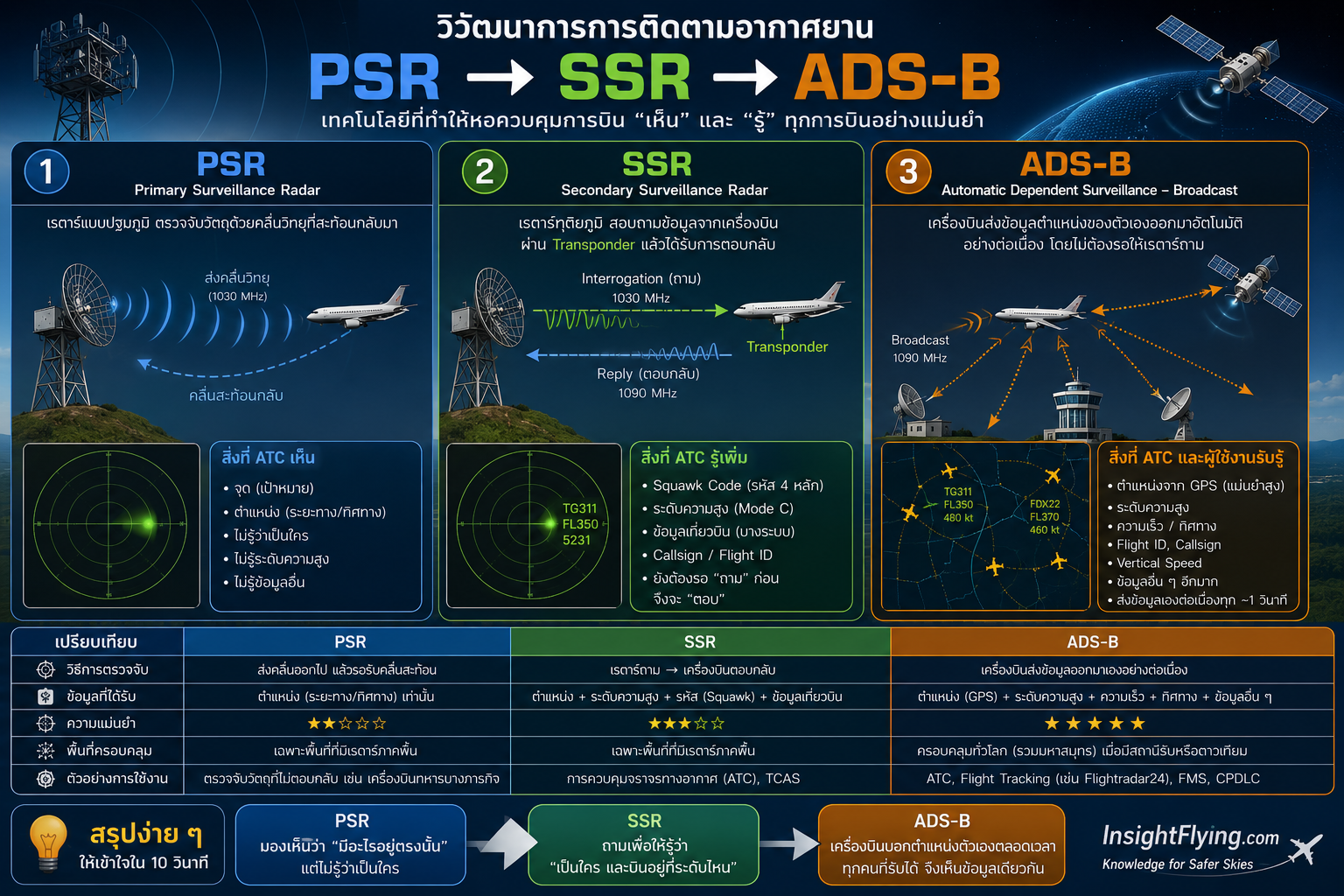
เมื่อเปิดเว็บไซต์ติดตามเที่ยวบินอย่าง FlightRadar24 หรือ FlightAware หลายคนอาจเข้าใจว่า “เรดาร์” คือผู้ที่มองเห็นเครื่องบินทั้งหมดบนท้องฟ้า แต่ในความเป็นจริง ระบบติดตามอากาศยานในปัจจุบันอาศัยการทำงานร่วมกันของเทคโนโลยีหลายชนิด ซึ่งได้รับการพัฒนาอย่างต่อเนื่องจาก Primary Surveillance Radar (PSR) ไปสู่ Secondary Surveillance Radar (SSR) และล่าสุดคือ Automatic Dependent Surveillance – Broadcast (ADS-B) อินโฟกราฟิกนี้สรุปวิวัฒนาการของทั้งสามระบบไว้ในภาพเดียว พร้อมอธิบายหลักการทำงาน จุดเด่น ข้อจำกัด และความแตกต่างของแต่ละเทคโนโลยีอย่างเข้าใจง่าย ✈️ PSR (Primary Surveillance Radar) ✈️ SSR (Secondary Surveillance Radar) ✈️ ADS-B (Automatic Dependent Surveillance – Broadcast) แม้ว่าปัจจุบัน ADS-B จะได้รับการใช้งานอย่างแพร่หลาย แต่ PSR, SSR และ…
-
เมื่อชิ้นส่วนเครื่องยนต์พุ่งชนหน้าต่างห้องโดยสาร

ENGLISH version click here ผู้โดยสารเกือบถูกดูดออกจากเครื่องบิน… เกิดอะไรขึ้นกันแน่? เหตุการณ์ที่สร้างความตกใจให้กับผู้โดยสารและผู้ที่ติดตามข่าวการบินทั่วโลก คือกรณีที่เครื่องบินของสายการบิน Ryanair ต้องลงจอดฉุกเฉิน หลังเกิดเหตุชิ้นส่วนจากบริเวณเครื่องยนต์พุ่งชนลำตัวเครื่องบิน จนทำให้หน้าต่างห้องโดยสารได้รับความเสียหาย และเกิดการลดความดันภายในห้องโดยสารอย่างรวดเร็ว (Rapid Depressurization) มีรายงานว่า ผู้โดยสารที่นั่งติดกับหน้าต่างได้รับผลกระทบจากแรงดันอากาศอย่างรุนแรง ร่างกายถูกดึงเข้าหาช่องเปิดของหน้าต่าง ก่อนที่ผู้โดยสารคนอื่น ๆ และลูกเรือจะช่วยกันดึงกลับเข้ามาภายในห้องโดยสารได้อย่างปลอดภัย แม้ว่าข่าวหลายสำนักจะใช้คำว่า “เกือบถูกดูดออกจากเครื่องบิน” แต่ในทางวิศวกรรมการบิน สิ่งที่เกิดขึ้นมีรายละเอียดที่น่าสนใจมากกว่านั้น ความจริงแล้ว ผู้โดยสารถูก “ดูด” ออกไปหรือไม่? คำว่า “ถูกดูดออกจากเครื่องบิน” เป็นคำอธิบายที่เข้าใจง่ายสำหรับคนทั่วไป แต่ในทางฟิสิกส์ สิ่งที่เกิดขึ้นคือ ความแตกต่างของความดันอากาศ (Pressure Differential) ระหว่างทำการบินที่ระดับความสูงประมาณ 35,000–40,000 ฟุต เมื่อหน้าต่างได้รับความเสียหายจนเกิดช่องเปิดขนาดใหญ่ อากาศภายในห้องโดยสารจะไหลออกสู่ภายนอกอย่างรวดเร็ว เพื่อให้ความดันทั้งสองด้านเข้าสู่สมดุล แรงลมที่เกิดขึ้นในช่วงเวลาสั้น ๆ นี้เอง ที่สามารถดึงสิ่งของหรือแม้แต่ร่างกายของผู้โดยสารที่อยู่ใกล้ช่องเปิดให้เคลื่อนเข้าหาหน้าต่างได้ ดังนั้น สิ่งที่เกิดขึ้นไม่ใช่ “สูญญากาศดูด” แต่เป็น การไหลของอากาศจากบริเวณที่มีความดันสูงไปยังบริเวณที่มีความดันต่ำ Rapid Depressurization คืออะไร?…
-
เส้นทางสู่ฝัน การเป็นนักบินพาณิชย์
การเป็นนักบินพาณิชย์ หรือ An Airline Pilot นั้นแต่ละคนมีเส้นทางเดินเพื่อสู่เป้าหมายที่แตกต่างกันไป แต่สำหรับผมไม่เคยนึกไฝ่ฝันอยากเป็นนักบินมาก่อนเลย ตั้งแต่เข้าช่วงเริ่มเป็นวัยรุ่น ก็มุ่งมั่นแต่การทำความเข้าใจเรื่องต่าง ๆ ที่กำลังเรียน พอจบม. 3 ก็สอบชิงทุนพสวท. ก็รับทุนตั้งแต่ม.4 จึงไม่เคยวาดฝันถึงการมีอาชีพเป็นนักบินเลยสักนิด เพราะว่าไม่เคยรับรู้ว่าการเป็นนักบินต้องทำอย่างไรบ้างหรือเป็นนักบินแล้วดีอย่างไร ชมวีดีโอ จากตัวอย่างบางตอนในหนังสือ A Pilot Book Part II ซื้อหนังสือเล่มจริงได้ทาง Shopee A Pilot Book A Pilot Part II Captain Sopon Phikanesuan www.mebmarket.com หนังสือ A Pilot Part II สำหรับผู้สนใจด้านการบินและเกร็ดความรู้สำหรับผู้โดยสารเพื่อความปลอดภัยในการเดินทาง แอดไลน์ https://line.me/R/ti/p/%40a-pilot เ… Get it now ชมคลิปวีดีโอที่นี่ครับ Share on FacebookPost on XFollow…




Pingback:Precipitation / การตกของฝนหรือหิมะ - Insight Flying