ในโลกยุคปัจจุบัน เราสามารถเปิดแอปแผนที่บนโทรศัพท์มือถือ ดูตำแหน่งของตนเองแบบ Real-Time หรือแม้แต่ติดตามเครื่องบินที่กำลังบินอยู่เหนือมหาสมุทรได้อย่างง่ายดาย แต่กว่าที่มนุษย์จะเดินทางมาถึงยุคของ GPS และดาวเทียมนำทางนั้น โลกเคยผ่านช่วงเวลาที่ “การรู้ว่าตนเองอยู่ตรงไหน” เป็นหนึ่งในความท้าทายที่ยิ่งใหญ่ที่สุดของมนุษยชาติ
ก่อนจะมีเครื่องบิน ก่อนจะมีแผนที่ดิจิทัล หรือระบบนำร่องอัตโนมัติ มนุษย์เริ่มต้นการเดินทางจาก “ทะเล” การเดินเรือในอดีตเต็มไปด้วยความเสี่ยง ลูกเรือต้องเผชิญกับพายุ กระแสน้ำ หมอก และมหาสมุทรอันกว้างใหญ่ที่ไม่มีป้ายบอกทาง ไม่มีถนน และไม่มีจุดอ้างอิงเหมือนบนพื้นดิน สิ่งเดียวที่ช่วยนำทางพวกเขาได้คือดวงดาว ดวงอาทิตย์ เข็มทิศ และความเข้าใจในธรรมชาติของโลก
ศาสตร์แห่งการนำทางจึงถือกำเนิดขึ้นจากความพยายามของมนุษย์ที่จะตอบคำถามง่าย ๆ แต่สำคัญที่สุดข้อหนึ่งว่า
“ตอนนี้เราอยู่ที่ไหนบนโลก?”
และคำถามเดียวกันนี้เอง ได้กลายเป็นรากฐานสำคัญของระบบการบินสมัยใหม่ในเวลาต่อมา
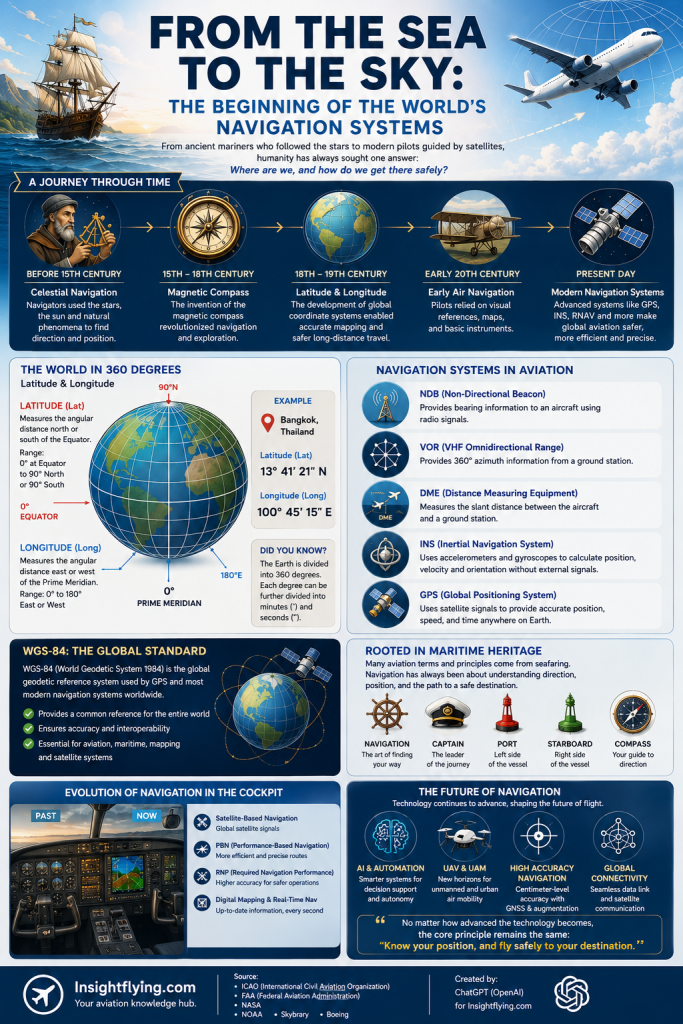
โลกกลม และการกำหนดตำแหน่ง
หนึ่งในความท้าทายสำคัญของการเดินทางระยะไกลคือ โลกไม่ได้แบน แต่เป็นทรงกลม การเดินทางจากจุดหนึ่งไปอีกจุดหนึ่งจึงไม่สามารถอ้างอิงด้วยเส้นตรงบนกระดาษได้เสมอไป มนุษย์จึงเริ่มสร้างระบบพิกัดขึ้นมาเพื่อกำหนดตำแหน่งบนโลกอย่างเป็นมาตรฐาน
ระบบที่ถูกใช้งานทั่วโลกคือ “Latitude และ Longitude” หรือ ละติจูดและลองจิจูด
- ละติจูด (Latitude) คือเส้นสมมุติที่วัดตำแหน่งเหนือหรือใต้ของเส้นศูนย์สูตร
- ลองจิจูด (Longitude) คือเส้นสมมุติที่วัดตำแหน่งทางตะวันออกหรือทางตะวันตกจากเส้นเมริเดียนหลักที่เมืองกรีนิช ประเทศอังกฤษ
โลกถูกแบ่งออกเป็นมุม 360 องศา เพื่อให้สามารถระบุตำแหน่งได้อย่างแม่นยำ หลักการนี้กลายเป็นพื้นฐานสำคัญของทั้งการเดินเรือ การทำแผนที่ และการบิน
ในโลกของการบิน นักบินทุกคนต้องเข้าใจระบบพิกัดเหล่านี้ เพราะทุกสนามบิน ทุกเส้นทางบิน และทุกจุดนำร่องบนโลก ล้วนถูกกำหนดด้วยพิกัดทางภูมิศาสตร์ทั้งหมด
จากเข็มทิศสู่ระบบนำร่องสมัยใหม่
ในอดีต นักเดินเรือใช้ “Celestial Navigation” หรือการนำทางด้วยดวงดาว พวกเขาศึกษาตำแหน่งของดวงอาทิตย์ ดวงจันทร์ และดาวเหนือ เพื่อคำนวณตำแหน่งของเรือกลางทะเล
ต่อมา “เข็มทิศแม่เหล็ก” ได้กลายเป็นหนึ่งในนวัตกรรมที่เปลี่ยนโลก เพราะช่วยให้มนุษย์สามารถกำหนดทิศทางได้แม้ในวันที่มองไม่เห็นดวงดาว
เมื่อเข้าสู่ยุคการบิน เทคโนโลยีการนำทางพัฒนาอย่างรวดเร็ว เครื่องบินยุคแรกใช้การมองเห็นภูมิประเทศด้านล่าง หรือที่เรียกว่า Visual Navigation นักบินจะอาศัยแม่น้ำ ถนน เมือง หรือชายฝั่งในการระบุตำแหน่ง
แต่เมื่อการบินพัฒนาไปสู่การบินกลางคืน การบินเหนือเมฆ และการบินข้ามมหาสมุทร ระบบนำทางแบบเดิมไม่เพียงพออีกต่อไป จึงเกิดเทคโนโลยีใหม่ขึ้น เช่น
- NDB (Non-Directional Beacon)
- VOR (VHF Omnidirectional Range)
- DME (Distance Measuring Equipment)
- INS (Inertial Navigation System)
- GPS (Global Positioning System)
ระบบเหล่านี้ช่วยให้เครื่องบินสามารถรู้ตำแหน่ง ความเร็ว ทิศทาง และเส้นทางบินได้อย่างแม่นยำ แม้จะอยู่เหนือมหาสมุทรหรือพื้นที่ที่ไม่มีจุดอ้างอิงบนพื้นดินเลยก็ตาม
WGS-84 ภาษากลางของโลกยุคใหม่
แม้โลกจะมีแผนที่มากมายหลายรูปแบบ แต่ปัญหาสำคัญคือ หากแต่ละประเทศใช้มาตรฐานพิกัดไม่เหมือนกัน ตำแหน่งเดียวกันอาจคลาดเคลื่อนได้หลายร้อยเมตร
จึงเกิดระบบมาตรฐานที่เรียกว่า World Geodetic System หรือ WGS ขึ้น และเวอร์ชันที่ใช้งานแพร่หลายที่สุดในปัจจุบันคือ WGS-84
WGS-84 เป็นระบบอ้างอิงพิกัดโลกที่ใช้ร่วมกันทั่วโลก ทั้งในระบบ GPS การบิน การเดินเรือ การทำแผนที่ และระบบดาวเทียมต่าง ๆ
พูดง่าย ๆ คือ หากไม่มี WGS-84 โลกยุคปัจจุบันอาจไม่สามารถมี GPS ที่แม่นยำ หรือระบบการบินที่เชื่อมต่อกันทั่วโลกได้เหมือนทุกวันนี้
เมื่อทะเลเชื่อมต่อสู่ท้องฟ้า
แม้การบินจะดูเป็นเทคโนโลยีสมัยใหม่ แต่รากฐานสำคัญจำนวนมากกลับเริ่มต้นจาก “การเดินเรือ”
คำศัพท์ทางการบินหลายคำมีต้นกำเนิดจากการเดินเรือ เช่น Navigation, Captain, Port, Starboard หรือแม้แต่หลักการคำนวณพิกัดและการใช้เข็มทิศ
นักบินในยุคแรกจำนวนมากก็เรียนรู้ศาสตร์การนำทางจากนักเดินเรือ และพัฒนาต่อจนกลายเป็นระบบการบินสมัยใหม่
จากเรือไม้ที่ล่องกลางมหาสมุทร สู่เครื่องบินเจ็ตที่บินสูงกว่า 35,000 ฟุต มนุษย์ยังคงใช้หลักการพื้นฐานเดียวกัน นั่นคือ
“การรู้ตำแหน่งของตนเองบนโลก และการหาทางไปยังจุดหมายอย่างปลอดภัย”
โลกอนาคตของ Navigation
ปัจจุบัน ระบบนำทางกำลังก้าวเข้าสู่ยุคใหม่อย่างรวดเร็ว ไม่ว่าจะเป็น
- Satellite-Based Navigation
- Performance-Based Navigation (PBN)
- Required Navigation Performance (RNP)
- ระบบนำร่องอัตโนมัติด้วย AI
- Digital Mapping และ Real-Time Navigation
ในอนาคต เครื่องบินไร้คนขับ Urban Air Mobility และระบบขนส่งทางอากาศอัตโนมัติ จะยิ่งพึ่งพาความแม่นยำของระบบพิกัดและ Navigation มากขึ้นกว่าเดิม
แต่ไม่ว่าเทคโนโลยีจะก้าวไกลเพียงใด หลักพื้นฐานยังคงเหมือนเดิมกับที่นักเดินเรือในอดีตเคยใช้ นั่นคือการเข้าใจโลก เข้าใจทิศทาง และเข้าใจตำแหน่งของตนเอง
บทสรุป
จากดวงดาวเหนือมหาสมุทร สู่ดาวเทียมที่โคจรรอบโลก ระบบนำทางคือหนึ่งในสิ่งประดิษฐ์ที่สำคัญที่สุดของมนุษยชาติ
มันไม่ได้เป็นเพียงเทคโนโลยีสำหรับนักบินหรือกัปตันเรือเท่านั้น แต่เป็นรากฐานของโลกสมัยใหม่ ตั้งแต่การเดินทาง การขนส่ง การสื่อสาร ไปจนถึงระบบเศรษฐกิจระดับโลก
ทุกครั้งที่เราเปิดแผนที่บนโทรศัพท์ หรือทุกครั้งที่เครื่องบินบินข้ามทวีปอย่างแม่นยำ เรากำลังใช้ผลลัพธ์จากองค์ความรู้ที่มนุษย์พัฒนามานานหลายศตวรรษ
ทั้งหมดเริ่มต้นจากคำถามง่าย ๆ กลางทะเลกว้างว่า
“เราอยู่ตรงไหนบนโลกใบนี้?”
From the Sea to the Sky: The Beginning of the World’s Navigation Systems
Introduction
Today, we can open a map application on our smartphones, track our exact location in real time, or even follow an aircraft flying across the ocean. However, long before GPS and satellite navigation existed, knowing one’s position on Earth was one of humanity’s greatest challenges.
Before aircraft, digital maps, or automated flight management systems, human exploration began at sea. Ancient sailors faced storms, currents, fog, and endless oceans without roads or signposts. Their only guides were the stars, the Sun, magnetic compasses, and their understanding of the Earth itself.
The science of navigation was born from humanity’s attempt to answer one fundamental question:
“Where are we on Earth?”
That same question later became the foundation of modern aviation navigation systems.
A Round Earth and the Need for Coordinates
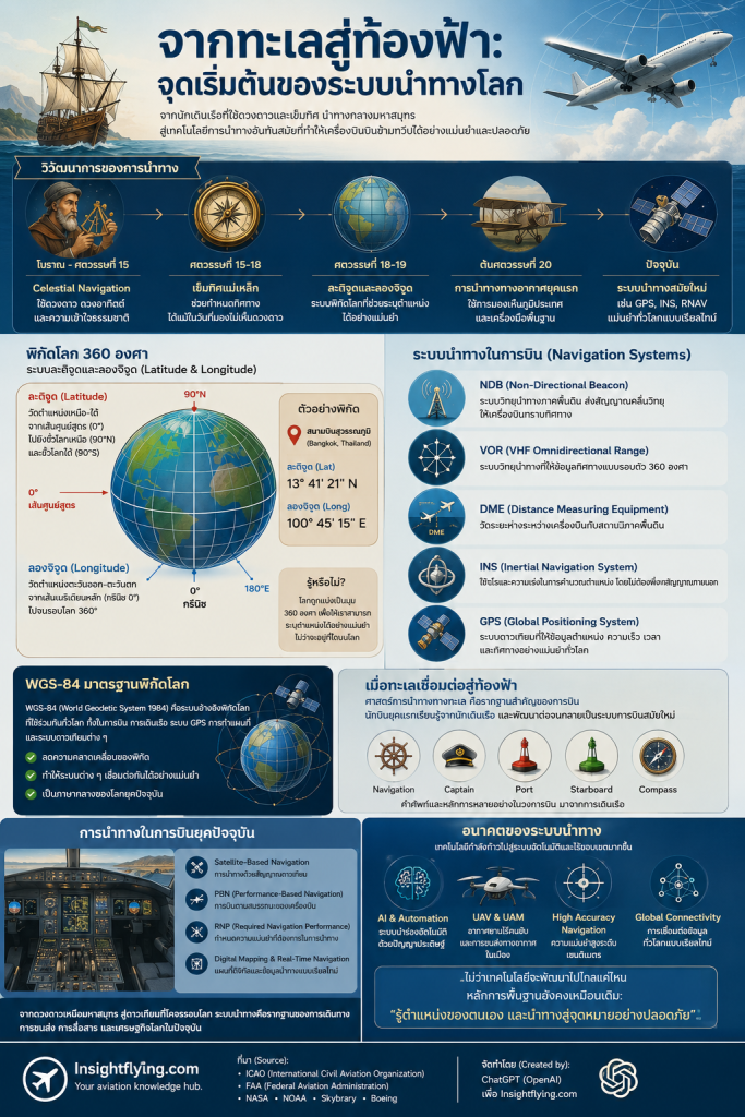
One of the greatest challenges of long-distance travel is that the Earth is not flat — it is spherical. To solve this problem, humans developed a coordinate system capable of defining positions anywhere on Earth.
This system became known as Latitude and Longitude.
- Latitude measures positions north or south of the Equator.
- Longitude measures positions east or west of the Prime Meridian in Greenwich, England.
The Earth was divided into 360 degrees, allowing locations to be identified with remarkable precision. This concept became essential for navigation, cartography, maritime operations, and eventually aviation.
In aviation, every airport, airway, waypoint, and navigation fix is defined by geographic coordinates.
From Compasses to Modern Navigation
Ancient mariners relied on celestial navigation, using the Sun, Moon, and stars to determine their position at sea.
The invention of the magnetic compass revolutionized navigation by allowing sailors to determine direction even without visible stars.
Early pilots later adopted many of these navigation principles. In the beginning of aviation, pilots navigated visually by following rivers, railways, coastlines, and cities below them.
However, as aviation expanded into night flying, instrument flying, and transoceanic operations, more advanced systems became necessary. This led to the development of technologies such as:
- NDB (Non-Directional Beacon)
- VOR (VHF Omnidirectional Range)
- DME (Distance Measuring Equipment)
- INS (Inertial Navigation System)
- GPS (Global Positioning System)
These systems allow aircraft to determine their position, direction, speed, and route with extraordinary accuracy, even over remote oceans or areas without ground references.
WGS-84: A Common Language for the Modern World
Different countries once used different mapping systems, creating inconsistencies in positioning.
To solve this problem, the World Geodetic System (WGS) was developed. The most widely used version today is WGS-84.
WGS-84 serves as the global reference framework for GPS, aviation, maritime navigation, satellite systems, and digital mapping worldwide.
Without WGS-84, the highly accurate global navigation systems we rely on today would not function consistently across international borders.
When the Sea Connected to the Sky
Although aviation appears modern, many of its navigation foundations originated from maritime traditions.
Terms such as Navigation, Captain, Port, and Starboard all came from seafaring history. Early aviators learned many navigation techniques directly from sailors and adapted them for flight.
From wooden ships crossing oceans to jet aircraft cruising above 35,000 feet, humanity has continued using the same essential principle:
“Know where you are, and know how to reach your destination safely.”
The Future of Navigation
Navigation technology continues to evolve rapidly through:
- Satellite-Based Navigation
- Performance-Based Navigation (PBN)
- Required Navigation Performance (RNP)
- AI-assisted navigation systems
- Digital mapping and real-time navigation
Future technologies such as unmanned aircraft, autonomous air transportation, and urban air mobility will depend even more heavily on highly accurate positioning systems.
Yet despite all technological advancements, the core principle remains unchanged from the days of ancient sailors:
Understanding the Earth, understanding direction, and understanding position.
Conclusion
From stars above the oceans to satellites orbiting the Earth, navigation systems represent one of humanity’s greatest achievements.
They are not merely tools for pilots or sailors, but fundamental technologies that support transportation, communication, trade, and the modern global economy.
Every time we open a digital map or board an aircraft crossing continents, we are benefiting from centuries of accumulated navigation knowledge.
And it all began with a simple question asked somewhere in the middle of the ocean:
“Where are we on this planet?”