
เมื่อมองขึ้นไปบนท้องฟ้า หลายคนอาจคิดว่าเครื่องบินสามารถบินไปทางไหนก็ได้ แต่ในความเป็นจริง การบินพาณิชย์ส่วนใหญ่ไม่ได้บินแบบอิสระ เครื่องบินจะต้องบินตาม “Airways” หรือ “เส้นทางบิน” ซึ่งเปรียบได้กับถนนหลวงบนท้องฟ้า เพื่อให้การจราจรทางอากาศมีความเป็นระเบียบ ปลอดภัย และสามารถรองรับปริมาณเที่ยวบินจำนวนมหาศาลได้พร้อมกัน
Airways ไม่ได้มีเพียงรูปแบบเดียว แต่แบ่งออกเป็นหลายประเภท ตามเทคโนโลยีการนำร่อง ความแม่นยำของระบบ และขีดความสามารถของเครื่องบิน
Airways คืออะไร
Airways คือเส้นทางการบินที่ถูกกำหนดไว้ล่วงหน้า เชื่อมต่อระหว่างจุดนำร่อง (Navigation Fixes / Waypoints / Navaids)
เครื่องบินจะใช้เส้นทางเหล่านี้ในการบินระหว่างสนามบินหนึ่งไปยังอีกสนามบินหนึ่ง โดยอยู่ภายใต้การควบคุมของ Air Traffic Control (ATC)
ในอดีต Airways อาศัยสถานีวิทยุนำร่องภาคพื้นดินเป็นหลัก แต่ปัจจุบันกำลังเปลี่ยนเข้าสู่ยุคของดาวเทียมและระบบนำร่องแบบ Area Navigation (RNAV)
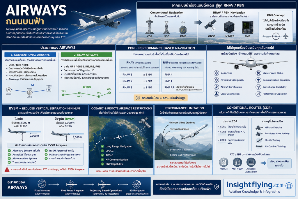
ประเภทของ Airways
1. Conventional Airways
เป็นเส้นทางบินแบบดั้งเดิม อ้างอิงจากสถานีวิทยุนำร่องภาคพื้นดิน เช่น
- VOR (VHF Omnidirectional Range)
- NDB (Non-Directional Beacon)
- DME (Distance Measuring Equipment)
เครื่องบินจะบิน “จากสถานีหนึ่งไปยังอีกสถานีหนึ่ง”
ตัวอย่างเช่น
- Airway A1
- Airway B345
- Jet Route Jxx
ข้อดีคือ:
- โครงสร้างง่าย
- ใช้งานมานาน
- เครื่องบินรุ่นเก่าก็สามารถบินได้
ข้อจำกัดคือ:
- ต้องพึ่งพาสถานีภาคพื้นดิน
- ความยืดหยุ่นต่ำ
- เส้นทางอาจไม่ตรงที่สุด
- Coverage จำกัดตามระยะของสัญญาณ
2. RNAV Routes
RNAV (Area Navigation) คือการนำร่องที่ไม่จำเป็นต้องบินตรงผ่านสถานีวิทยุภาคพื้นดินอีกต่อไป
เครื่องบินสามารถบิน “ตรง” ระหว่าง waypoint ต่าง ๆ ได้ โดยอาศัย:
- GPS / GNSS
- INS / IRS
- Flight Management System (FMS)
RNAV routes ช่วยให้:
- ประหยัดเชื้อเพลิง
- ลดระยะทางบิน
- ลด workload ของ ATC
- เพิ่ม capacity ของห้วงอากาศ
ตัวอย่างเช่น:
- Q Routes
- T Routes
- PBN Routes
PBN — Performance Based Navigation
ปัจจุบันโลกการบินกำลังเปลี่ยนจาก “sensor-based navigation” ไปสู่ “performance-based navigation”
แนวคิดสำคัญคือ:
“ไม่ได้ดูว่าใช้เครื่องมืออะไร แต่ดูว่าเครื่องบินบินได้แม่นยำแค่ไหน”
PBN แบ่งออกหลัก ๆ เป็น:
RNAV
กำหนดความแม่นยำขั้นต่ำ เช่น
- RNAV 5
- RNAV 2
- RNAV 1
ตัวเลขหมายถึงความคลาดเคลื่อนที่ยอมรับได้ (Nautical Miles)
ตัวอย่าง:
RNAV 5 หมายถึงเครื่องบินต้องรักษาตำแหน่งให้อยู่ภายใน ±5 NM ได้อย่างน้อย 95% ของเวลาบิน
RNP (Required Navigation Performance)
พัฒนาต่อจาก RNAV โดยมีระบบ Monitoring และ Alerting ในตัว
เช่น:
- RNP 4
- RNP 1
- RNP AR
RNP มีความแม่นยำสูงกว่า และเหมาะกับพื้นที่ซับซ้อน เช่น:
- หุบเขา
- สนามบิน surrounded terrain
- Oceanic airspace
ไม่ใช่ทุกเครื่องบินจะบินทุกเส้นทางได้
นี่คือเรื่องสำคัญมากในงาน Flight Operations และ Dispatch
แม้เส้นทางจะเปิดใช้งาน แต่เครื่องบินต้อง “มีคุณสมบัติ” ตรงตามข้อกำหนดก่อน
ข้อจำกัดอาจมาจาก:
- ระบบนำร่อง
- ความแม่นยำของอุปกรณ์
- Aircraft certification
- Crew qualification
- Maintenance status
ตัวอย่างข้อจำกัดสำคัญ
1. RVSM — Reduced Vertical Separation Minimum
ในอดีต เครื่องบินเหนือ FL290 ต้องเว้นระยะสูง 2,000 ฟุต
แต่เมื่อเทคโนโลยีมีความแม่นยำมากขึ้น จึงลดเหลือ 1,000 ฟุตได้
นี่คือ RVSM
1000\ ft
ผลคือ:
- เพิ่มจำนวนระดับบิน
- เพิ่ม capacity
- ลด fuel burn
- ช่วยให้ aircraft ได้ optimum altitude มากขึ้น
แต่การจะบินใน RVSM airspace ได้ เครื่องบินต้องมี:
- Altimetry system ที่แม่นยำ
- Autopilot ที่ได้มาตรฐาน
- Altitude alert system
- Transponder ที่ถูกต้อง
- Maintenance program เฉพาะ
- RVSM approval จากรัฐผู้กำกับดูแล
หากระบบบางอย่างเสีย เช่น:
- Altitude keeping unreliable
- Autopilot failure
- ADS-C / CPDLC issue ในบางพื้นที่
ATC อาจ:
- ไม่อนุญาตให้เข้า RVSM airspace
- บังคับให้บิน lower level
- จำกัด route
ซึ่งมีผลต่อ:
- Fuel
- Payload
- เวลาเดินทาง
2. Oceanic & Remote Airspace Restrictions
พื้นที่มหาสมุทร เช่น:
- North Atlantic
- Pacific
- Polar routes
มีข้อกำหนดสูงมาก เพราะไม่มี radar coverage แบบปกติ
เครื่องบินอาจต้องมี:
- Long Range Navigation capability
- CPDLC
- ADS-C
- HF communication
- RNP capability
หากไม่ครบ อาจไม่สามารถใช้เส้นทางที่ดีที่สุดได้
3. Performance Limitation
บางเส้นทางมีข้อจำกัดด้านสมรรถนะเครื่องบิน เช่น
- Minimum climb gradient
- Drift down capability
- Terrain clearance
- Engine-out performance
ตัวอย่าง:
สนามบิน surrounded terrain หรือ airway ผ่านภูเขาสูง
หาก aircraft performance ไม่เพียงพอ:
- อาจถูกจำกัดน้ำหนัก
- จำกัดระดับบิน
- หรือใช้ route ไม่ได้เลย
Conditional Routes (CDR) — เส้นทางที่เปิดเป็นบางเวลา
นี่คือเรื่องที่น่าสนใจมาก โดยเฉพาะในยุโรปและพื้นที่ที่มีกิจกรรมทางทหารสูง
บาง airway ไม่ได้เปิดตลอดเวลา
เพราะ:
- Military exercise
- Restricted area activity
- Missile testing
- Air combat training
จึงเกิดแนวคิด:
Conditional Routes (CDR)
แบ่งได้เช่น:
- CDR1 — ใช้งานได้ตามเงื่อนไข
- CDR2 — วางแผนล่วงหน้าได้ แต่ ATC อาจปิด
- CDR3 — ปิดถาวรในช่วงเวลาหนึ่ง
ATC และ Network Flow Management จะประกาศว่า:
- Route ไหนเปิด
- Route ไหนปิด
- ใช้ได้เวลาใด
นักบินและพนักงานอำนวยการบินต้องตรวจสอบ:
- NOTAM
- AUP/UUP
- Airspace availability
ก่อนวางแผนการบินทุกครั้ง
Flexible Use of Airspace (FUA)
แนวคิดสมัยใหม่คือ:
“ห้วงอากาศไม่ได้เป็นของพลเรือนหรือทหารตลอดเวลา”
แต่สามารถแบ่งใช้ร่วมกันแบบ Dynamic ได้
ช่วงที่ทหารไม่ได้ใช้งาน:
- เปิดให้ civil traffic ใช้
- ลด congestion
- ลด delay
- ประหยัดเชื้อเพลิง
เมื่อทหารต้องใช้:
- พื้นที่จะถูก activate
- Airways บางเส้นจะปิดชั่วคราว
นี่คือเหตุผลว่าทำไม flight plan บางวันบินตรงได้ แต่บางวันต้องอ้อม
Airway ไม่ได้มีไว้แค่ “บอกทาง”
จริง ๆ แล้ว Airways คือโครงสร้างหลักของ Air Traffic Management ทั้งระบบ
มันเกี่ยวข้องกับ:
- Separation
- Capacity
- Safety
- Fuel efficiency
- Military coordination
- Navigation capability
- Aircraft certification
- Crew competency
เมื่อเทคโนโลยีพัฒนา โลกกำลังเปลี่ยนจาก:
- Fixed airways
ไปสู่: - Free Route Airspace
- Trajectory Based Operations
- 4D Navigation
ในอนาคต เครื่องบินอาจไม่ได้ “เกาะถนนบนฟ้า” แบบเดิมอีกต่อไป แต่จะบินบน trajectory ที่ dynamic และ optimized แบบ real-time มากขึ้น
แต่ไม่ว่าจะเทคโนโลยีก้าวหน้าแค่ไหน หลักการสำคัญยังคงเดิม:
“ความแม่นยำ ความสามารถของระบบ และวินัยในการบิน คือหัวใจของความปลอดภัยบนท้องฟ้า”
Airways — The Highways in the Sky
When we look up at the sky, it may seem that aircraft can simply fly freely from one place to another. In reality, however, most commercial aircraft operate along predefined routes known as “Airways” — the highways of the sky.
These routes help organize air traffic, maintain safe separation between aircraft, and allow thousands of flights to operate efficiently every day across the world.
Airways are not all the same. They vary depending on navigation technology, aircraft capability, airspace structure, and operational requirements.
What Are Airways?
Airways are predefined flight routes connecting navigation fixes, waypoints, or radio navigation aids.
Aircraft use these routes to travel between airports under the supervision of Air Traffic Control (ATC).
Traditionally, airways were built around ground-based navigation stations. Today, aviation is rapidly transitioning toward satellite-based navigation and Performance-Based Navigation (PBN).
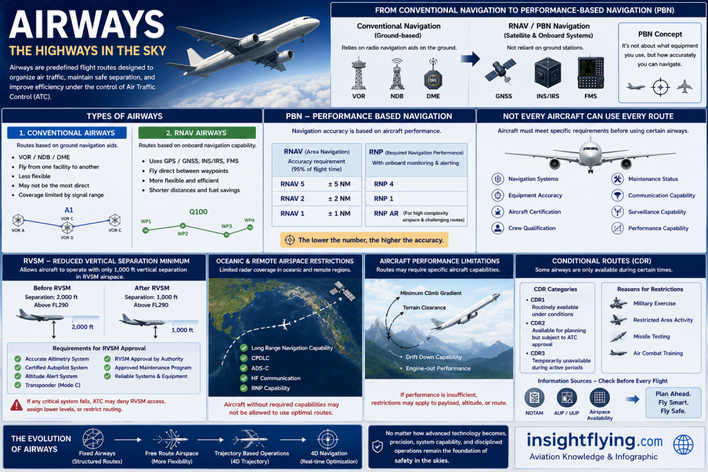
Types of Airways
1. Conventional Airways
Conventional airways are the traditional route structure based on ground navigation aids such as:
- VOR (VHF Omnidirectional Range)
- NDB (Non-Directional Beacon)
- DME (Distance Measuring Equipment)
Aircraft typically fly from one navigation station to another.
Examples include:
- Jet Routes
- Victor Airways
- Airway structures such as A, B, or J routes
Advantages:
- Simple and well established
- Compatible with older aircraft
- Reliable in conventional airspace
Limitations:
- Dependent on ground infrastructure
- Limited flexibility
- Routes are often less direct
- Signal coverage is limited by distance and terrain
2. RNAV Routes
RNAV (Area Navigation) allows aircraft to fly between any defined waypoints without relying solely on ground-based navigation stations.
RNAV systems use:
- GPS / GNSS
- INS / IRS
- Flight Management Systems (FMS)
This enables aircraft to:
- Fly more direct routes
- Reduce fuel consumption
- Improve airspace efficiency
- Reduce ATC workload
Examples include:
- Q Routes
- T Routes
- PBN Routes
RNAV has become a major foundation of modern air traffic management.
Performance-Based Navigation (PBN)
Modern aviation is shifting from “sensor-based navigation” to “performance-based navigation.”
Instead of focusing on which navigation equipment an aircraft uses, PBN focuses on how accurately the aircraft can navigate.
PBN is mainly divided into:
RNAV
RNAV specifications define navigation accuracy requirements, such as:
- RNAV 5
- RNAV 2
- RNAV 1
The number indicates the maximum allowable navigation error in nautical miles.
For example:
RNAV 5 means the aircraft must remain within ±5 nautical miles of the intended track for at least 95% of the flight time.
RNP (Required Navigation Performance)
RNP is an advanced form of RNAV with onboard performance monitoring and alerting capability.
Examples include:
- RNP 4
- RNP 1
- RNP AR
RNP operations provide higher precision and are commonly used in:
- Mountainous terrain
- Challenging airport environments
- Oceanic and remote airspace
Not Every Aircraft Can Use Every Route
This is one of the most important concepts in flight operations and dispatch.
Even if an airway is available, the aircraft must meet specific operational and certification requirements before using it.
Restrictions may depend on:
- Navigation systems
- Aircraft certification
- Equipment capability
- Crew qualification
- Maintenance status
- Communication and surveillance capability
RVSM — Reduced Vertical Separation Minimum
One of the most significant developments in modern airspace management is RVSM.
In the past, aircraft flying above FL290 required 2,000 feet of vertical separation.
With improved navigation and altitude-keeping technology, this separation was reduced to 1,000 feet.
2000\ ft \rightarrow 1000\ ft
Benefits include:
- Increased airspace capacity
- More available flight levels
- Improved fuel efficiency
- Better access to optimum cruising altitude
However, aircraft must meet strict requirements to operate in RVSM airspace, including:
- Highly accurate altimetry systems
- Certified autopilot systems
- Altitude alert systems
- Proper transponder capability
- Approved maintenance programs
- Regulatory RVSM approval
If critical systems fail, ATC may:
- Deny RVSM airspace entry
- Assign lower altitudes
- Restrict routing options
This can significantly impact:
- Fuel burn
- Payload
- Flight time
- Operational efficiency
Oceanic and Remote Airspace Restrictions
Oceanic and remote regions such as:
- The North Atlantic
- Pacific routes
- Polar operations
often lack conventional radar coverage.
Aircraft operating in these areas may require:
- Long-range navigation capability
- CPDLC
- ADS-C
- HF communication
- Specific RNP approvals
Aircraft lacking these capabilities may be unable to use preferred routes or optimum altitudes.
Aircraft Performance Limitations
Some routes impose additional aircraft performance requirements, including:
- Minimum climb gradients
- Terrain clearance capability
- Drift-down performance
- Engine-out performance
This is particularly important in:
- Mountainous regions
- High terrain environments
- Airports surrounded by obstacles
If aircraft performance is insufficient, operators may need to:
- Restrict payload
- Limit cruising altitude
- Select alternative routes
- Apply weight penalties
Conditional Routes (CDR)
Not all airways are available all the time.
In many parts of the world — especially where military activity is common — certain routes may only be available during specific periods.
These are known as Conditional Routes (CDR).
Examples:
- CDR1 — Routinely available under conditions
- CDR2 — Available for planning but subject to ATC approval
- CDR3 — Temporarily unavailable during active periods
Routes may be restricted due to:
- Military exercises
- Restricted airspace activation
- Missile testing
- Air combat training
Flight crews and dispatchers must carefully monitor:
- NOTAMs
- Airspace Use Plans (AUP/UUP)
- Route availability messages
before every flight.
Flexible Use of Airspace (FUA)
Modern airspace management increasingly uses the concept of Flexible Use of Airspace (FUA).
The idea is simple:
Airspace is not permanently reserved for either civil or military operations.
Instead, it can be dynamically shared.
When military airspace is inactive:
- Civil aircraft may use it
- Congestion can be reduced
- Flights become more efficient
- Fuel savings improve
When military operations begin:
- Airspace may be temporarily closed
- Airways may become unavailable
- Aircraft may need rerouting
This explains why some flights can fly direct one day but require significant deviations the next.
Airways Are More Than Just “Routes”
Airways form the backbone of the global Air Traffic Management system.
They influence:
- Safety
- Separation
- Capacity
- Fuel efficiency
- Airspace coordination
- Military integration
- Aircraft certification
- Navigation performance
As aviation technology continues to evolve, the industry is gradually moving from:
- Fixed airways
toward: - Free Route Airspace
- Trajectory-Based Operations
- 4D Navigation
- Real-time optimized routing
In the future, aircraft may no longer follow rigid “roads in the sky” in the traditional sense. Instead, flights will increasingly operate along dynamic, optimized trajectories calculated in real time.
But regardless of how advanced technology becomes, one principle remains unchanged:
Precision, system capability, and disciplined operations remain the foundation of safety in the skies.
— insightflying.com